| >> |
National Estuarine Research Reserve Sapelo Island enables visitors to see virtually every facet of a barrier islands’s natural community, from the diversified wildlife of the forested uplands, to the vast expanses of salt marsh and the complex beach and dunes systems. The Visitor Center, located near the mainland ferry dock brings to life both the natural and cultural history of Sapelo, while guided tours of the island enable visitors to experience thc African-American community of Flog Hammock the University of Georgia Marine Institute , the Reynolds Mansion and Sapelo Island’s 1820 Lighthouse. SAPELO ISLAND VISITORS CENTER 912 437 3224 in Meridian is open daily except Mondays. This interpretive center for Sapelo has much to offer Reservations for the four hour regular tours of the Island on Wednesdays, Fridays and Saturdays. And the six hour extended tour on the 1ast Tuesday of each month are made here. A Gift Shop which includes Books, Art Objects, Pictures and Posters and wearing apparel is available at the Visitors Center. The SINERR is managed by the Georgia Department of Natural Resources, Wildlife Resources Division, and is administered by the National Oceanic and Atmospheric Administration (NOAA) |
|
| >> | ||
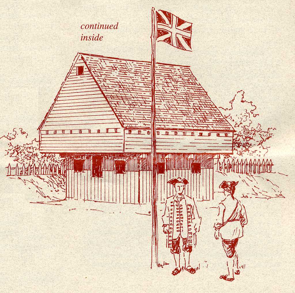 From
its construction in 1721 until it was abandoned in
1732, Fort King George was the southernmost outpost of the British Empire
in North America. Named for King George I of Britain, the fort was a
typical small European field fortification consisting of a triangular
earthwork-walled enclosure. Surrounded by a moat on two sides and the
north branch of the Altamaha River on the third, the fort’s main defense
was a 26-foot square blockhouse. A log palisade stood in the moat to deter
enemy soldiers and Indians from storming the fort from the land side. From
its construction in 1721 until it was abandoned in
1732, Fort King George was the southernmost outpost of the British Empire
in North America. Named for King George I of Britain, the fort was a
typical small European field fortification consisting of a triangular
earthwork-walled enclosure. Surrounded by a moat on two sides and the
north branch of the Altamaha River on the third, the fort’s main defense
was a 26-foot square blockhouse. A log palisade stood in the moat to deter
enemy soldiers and Indians from storming the fort from the land side.The gabled blockhouse had three stories: a powder, ammunition and supply magazine on the lower level, a gun room on the second floor with cannon ports in the walls for firing on enemy boats attacking by river, and a third floor used as a lookout post. A barracks, officers’ house and several smaller structures also stood within the fort. Fort King George’s blockhouse is a duplicate of the original structure. The 40-foot-high gabled building was reconstructed in 1988 using plans in the files of the British Public Records Office in London. Future plans call for reconstruction of the barracks and other structures of the fort. Long after the fort was abandoned, sawmills were erected on the site, eliminating traces of fortifications. Adjoining the fort is one of the oldest British military cemeteries in
the southeastern United States. It contains 65 graves including 15 marked
as the final resting place of British soldiers serving at Fort King
George. |
||
|
The Altamaha Bluff Indian and Spanish Occupation Indians known to the Spanish as Guale (pronounced wally) were the native inhabitants of this coastal area. In 1565, Spain sent Jesuit and Franciscan priests to this region to convert the Guale to Christianity and to establish centers of Spanish influence along the coast. After Charles Town (Charleston, South Carolina) was founded in 1670, the English incited Indian raids on .the coastal missions, forcing the Guale and Spanish to retreat to St. Augustine. British Occupation In 1720, Colonel John "Tuscarora Jack" Barnwell, a prominent South Carolina planter and Indian fighter, was sent to London to convince the Board of Trade to build a fort on the mouth of the Altamaha River. The French, established in Canada, along the Mississippi River and on the Gulf of Mexico, were infiltrating the Altamaha. With the Spanish also posing a threat in Florida, the British colonies along the coast would have been surrounded. The Board approved Barnwell’s proposal and agreed to build and garrison a fort to command the mouth of the Altamaha. For seven years an Independent Company encountered tremendous hardships from disease, threats by the Spanish and Indians, and fear of the unknown. The garrison withdrew back to South Carolina in 1727 but two lookouts kept watch here to warn of any invaders crossing the Altamaha. Though abandoned, the fort had established British dominion in the land that was to become Georgia. |
||